
The Distribution of Oceans and Continents is a dynamic and ever-changing process shaped by geological forces. Continents cover 29% of the Earth’s surface, while the rest is occupied by vast oceanic waters. However, the position of these landmasses has not always been the same.
Over millions of years, continents have shifted due to powerful geological processes. This blog explores the major theories related to the movement of oceans and continents, from the early ideas of continental drift to modern plate tectonics.
Download notes of Understanding the Interior of Earth
Theories of Continental and Oceanic Movements
1. Early Observations and Theories
Since the 16th century, geographers noticed the striking symmetry of the coastlines of continents across the Atlantic Ocean. Dutch mapmaker Abraham Ortelius suggested that the Americas, Europe, and Africa might have once been connected. Later, in the 19th century, Antonio Pellegrini illustrated maps showing the close fit of these landmasses.
However, it was Alfred Wegener who provided a systematic explanation in 1912 through his Continental Drift Theory.
2. Continental Drift Theory (1912) by Alfred Wegener
Wegener proposed that all continents were once part of a single supercontinent called Pangaea, surrounded by a mega-ocean, Panthalassa. Over time, Pangaea split into two large landmasses:
- Laurasia (Northern Hemisphere)
- Gondwanaland (Southern Hemisphere)
These further broke apart into the present-day continents.
Forces Proposed for the Drift:
- Pole-fleeing forces: Related to Earth’s rotation, causing continents to move outward toward the equator.
- Tidal forces: Gravitational attraction from the Moon and Sun, contributing to the westward movement of continents over long periods.
Although Wegener’s idea of continental drift was widely accepted, the proposed forces were found to be too weak to explain the movement.
Evidence Supporting Continental Drift
Several geological and fossil records support the theory of continental drift:
- Jig-Saw Fit: The shorelines of South America and Africa match remarkably when placed together.
- Matching Rock Ages Across Oceans: Similar rock formations on the coast of Brazil and West Africa suggest a shared geological past.
- Tillite Deposits: Found in India, Africa, and Australia, indicating past glaciation in these regions.
- Placer Deposits: The presence of gold deposits in Ghana with no local source suggests they originated from Brazil.
- Fossil Evidence: Identical plant and animal fossils found on different continents, supporting the idea that they were once connected.
3. Post-Drift Discoveries and Plate Tectonics
Although the Continental Drift Theory lacked a convincing mechanism, later discoveries solidified the concept of moving continents:
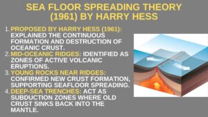
A. Sea Floor Spreading Theory (1961) by Harry Hess
- Mid-oceanic ridges were identified as zones of active volcanic activity.
- Rocks near ridges were younger, confirming continuous formation of oceanic crust.
- Deep-sea trenches were found to be subduction zones where old crust sinks back into the mantle.
B. Plate Tectonics (1967)
The Plate Tectonic Theory combined ideas from continental drift and seafloor spreading. Proposed by McKenzie, Parker, and Morgan, it describes Earth’s lithosphere as divided into rigid plates that move over the asthenosphere.
4. Types of Plate Boundaries
Tectonic activity occurs at plate boundaries, causing earthquakes and volcanoes. The three major types are:
- Divergent Boundaries: Plates move apart, forming new crust (e.g., Mid-Atlantic Ridge).
- Convergent Boundaries: Plates collide, causing subduction (e.g., Himalayas, Andes Mountains).
- Transform Boundaries: Plates slide past each other, leading to earthquakes (e.g., San Andreas Fault).
5. Movement of the Indian Plate
The Indian Plate includes Peninsular India and parts of Australia. Its movement led to the formation of the Himalayas and continues to shape Earth’s surface.
- 225 million years ago: India was an isolated island in the Tethys Sea.
- 50 million years ago: It collided with Asia, leading to the uplift of the Himalayas.
- Deccan Traps Formation (60 million years ago): Massive volcanic activity occurred during this time.
Earthquakes, Volcanoes, and Plate Tectonics
- Convergent boundaries: Cause deep earthquakes and volcanic eruptions (e.g., Ring of Fire around the Pacific Ocean).
- Divergent boundaries: Create mid-ocean ridges with shallow earthquakes.
- Transform boundaries: Result in major fault zones (e.g., San Andreas Fault).
The movement of continents and oceans has shaped Earth’s surface over millions of years. From continental drift to plate tectonics, scientists have developed an understanding of how Earth’s crust evolves. Ongoing studies of seafloor spreading, earthquakes, and volcanoes continue to provide insights into these geological processes.
Download notes of Origin and Evolution of Earth
FAQs related to Distribution of Oceans and Continents
1. What is the Distribution of Oceans and Continents?
It refers to the division of Earth’s surface into landmasses (continents) and water bodies (oceans), which have changed positions due to tectonic movements.
2. What is the main difference between continental drift and plate tectonics?
Continental drift explains the movement of continents, while plate tectonics describes the movement of large lithospheric plates, including oceanic and continental plates.
3. Why do earthquakes and volcanoes mostly occur along plate boundaries?
Tectonic plates interact at boundaries, causing stress and magma movement, leading to earthquakes and volcanic eruptions.
4. What is the Ring of Fire?
The Pacific Ring of Fire is a region surrounding the Pacific Ocean known for frequent earthquakes and volcanic activity due to active plate boundaries. Understanding the Distribution of Oceans and Continents is crucial for comprehending natural disasters, resource distribution, and Earth’s geological history.